

Map 2026
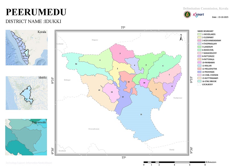
Peermedu Grama Panchayat Ward Delimitation Report – Analytical Overview
1. Background of the Report
Pursuant to Section 10 of the Kerala Panchayat Raj Act, 1994, the Delimitation Commission issued this order to redefine the ward boundaries and reconstitute the constituencies of Peermedu Grama Panchayat. The final order was promulgated after duly examining and addressing objections and suggestions submitted by the general public.
2. Number of Wards
While the Panchayat previously comprised 17 wards, the fresh order has reconstituted the jurisdiction into 16 wards.
New Wards
| Ward No. | Ward Name | Population |
|---|---|---|
| 1 | Woodlands | 1292 |
| 2 | Glenmary | 1288 |
| 3 | Koduwakaranam | 1305 |
| 4 | Theppakkulam | 1281 |
| 5 | Ladrum | 1329 |
| 6 | Ranikovil | 1466 |
| 7 | Karadikuzhy | 1484 |
| 8 | Pattumudi | 1316 |
| 9 | Pattumala | 1444 |
| 10 | Pambanar | 1471 |
| 11 | Kallar | 1486 |
| 12 | Melazhutha | 1257 |
| 13 | Peermedu | 1380 |
| 14 | Civil Station | 1263 |
| 15 | Kuttikkanam | 1420 |
| 16 | Stagbrook | 1230 |
3. Demographic Analysis
Wards with Highest Population
- Kallar – 1486
- Karadikuzhy – 1484
- Pambanar – 1471
- Ranikovil – 1466
Wards with Lowest Population
- Stagbrook – 1230
- Melazhutha – 1257
- Civil Station – 1263
- Theppakkulam – 1281
Observations
- The population across wards ranges approximately from 1230 to 1486.
- Demographic variance between wards remains well within permissible statutory limits.
- The delimitation successfully ensures equitable population representation across all wards.
4. Geographical Features
Ward boundaries of Peermedu Grama Panchayat have been defined primarily using:
- National Highway (NH)
- Streams and water channels
- Estate boundaries
- Major road junctions
- Temples and churches
- Viewpoints
- Forest reserve boundaries
as identifiable natural and physical demarcations.
5. Developmental Implications
Positive Factors
✅ Improved population balance
✅ Enables ward members to function more effectively and represent constituencies better
✅ Enhances efficient implementation and reach of government welfare schemes
✅ Provides distinct representation for varied geographical terrains including agriculture, tourism, forest fringes, and urban settlements
Challenges
⚠️ Need for widespread public awareness campaigns regarding redefined boundaries
⚠️ Administrative adjustments required for localities reassigned to different wards
⚠️ Requirement for updated electoral rolls and reorganized polling booth allocations
6. Alignment with Panchayat Development Vision
This delimitation provides vital administrative support for key development focus areas, including:
- Tourism development (Kuttikkanam, Peermedu, Stagbrook)
- Agricultural enhancement (Pambanar, Karadikuzhy, Pattumala)
- Core infrastructure expansion
- Solid and liquid waste management
- Water conservation initiatives
- Rural road network development
Conclusion
Under the 2025 Delimitation Report, Peermedu Grama Panchayat transitions into a more balanced, responsive, and efficient administrative structure consisting of 16 wards. The new territorial jurisdictions have been formed considering demographic equity, geographic rationale, and governance convenience, which will significantly streamline the implementation of local self-government initiatives in the years ahead.


